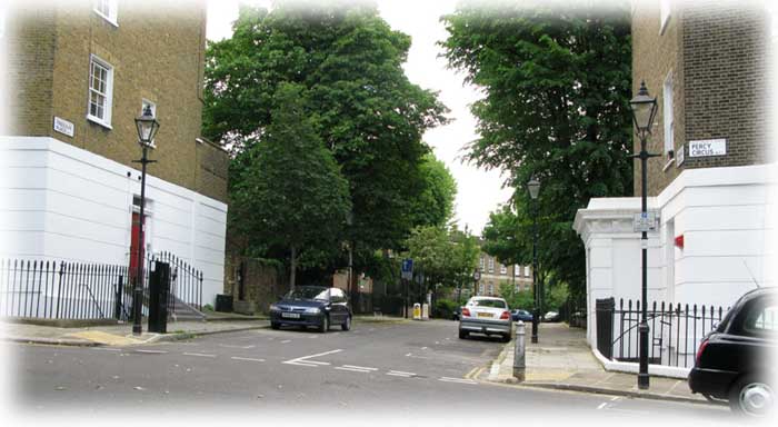
Percy Circus

The 1914 map of Percy Circus, Holford Square and Hugh Myddleton School.
The whole area was set out on a south-facing hillside, in classical layouts; a Circus, Squares and numerous Rectangles. It was a planned as a Classical estate layout, designed to be near the City of London but away from its old crowded houses. It could have come directly from some 18th Century architect's notebook when he returned from the Grand Tour. It was completely different from the traditional City of London layout. There the streets were narrow lanes. Here roads wer generously wide and laid out as vistas. Houses were large and impressive, not the narrow fronted, tall houses squeezed upwards by the old City walls.
The people who first moved into these houses had arrived'. They were the successful ones and could now enjoy the new, spacious houses. It was exactly like the contrast between the tenements of Old Edinburgh and Edinburgh New Town, laid out on its Classical grid.
The air was better in Percy Circus than in the City of London, but it was near King's Cross and Euston and would not be free of soot for another century and the Clean Air Acts of 1956, 1968 and 1990.
The houses were built as separate properties and some remained like this, but soon many were divided into floors and even separate rooms. Decades before 1939 and the Second World War, in it had become a densely packed area, full of bed-sitting rooms and single women. Their potential husbands had been killed in the First World War. The most relevant novel seems to me to be Riceyman Steps by Arnold Bennett, which is set nearby.
The Second World War
During the Second World War Percy Circus was bombed many times but by far the most serious damage was on 15th May 1941. The old Borough of Finsbury, now part of Islington, typed a sheet each day listing all the damage in the borough. This day's total is jaw-dropping.
The report page for the 24 hours ending 15th May 1941? states:-
 |
The sheets shown list each building and the approximate damage caused. The list goes on and on. No doubt the parachute prevented that bomb from penetrating the ground and its blast effect spread sideways, not upwards, causing damage to houses over a wide area. The high explosives increased this damage, so that the total destruction was extreme. |
After The Second World War.
The Creation of the 1939-45 War Damage Maps,
so that the Rebuilding of London could be planned properly.
Local Boroughs knew the damage in their own area, but a full picture was needed so that repair, demolition and rebuilding could be organised. People were desperate for homes. Town Halls were full of people demanding accommodation, so planning and the best allocation of scare building materials were urgent and the pressure to work quickly was intense.
By a lucky chance Finsbury has left us a few sketches which show how the final Bomb Damage Maps were compiled. Each borough must have been asked by the London County Council to make detailed sketches of their own damage. Architects and assistants traced small areas of the Ordnance Survey maps in Indian ink, coloured them in to show the degrees of the damage to each property, and sent them in. By doing it in small patches, the work could be shared out in the local offices and the task completed quickly. This was decades before coloured photocopiers, so the small pieces of map, with the damage marked with coloured pencil, were sent off to County Hall to be built up into the Bombing Maps we have today. The final maps became the basis for the Abercrombie Plan for the re-planning of London. No doubt most of the local sketches were then thrown away but by chance, about half a dozen Finsbury ones have survived.
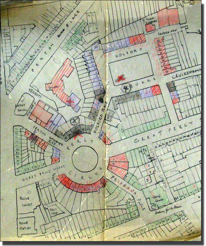
The War Damage to Percy Circus and Holford Square
Drawn of tracing paper and with the degrees of damage coloured in.
Reproduced by courtesy of Islington History Archive.
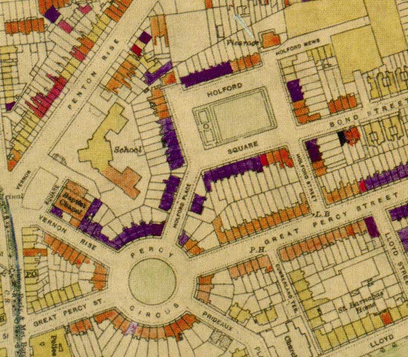
In 2005 The London County Council BOMB DAMAGE MAPS, 1939-1945' were printed by the London Topographical Society. This volume is invaluable and some small pieces have been reproduced here by kind permission of London Metropolitan Archive which owns the copyright. The book is out of print but a number of people have put down their names for copies if and when it is reprinted. Try the Internet but expect to pay a good price. It is a rare book.
 |
||
| Whole Map | Larger Area | Larger Area Map in New Window |
The Bomb Damage Map of Percy Circus
The Colour Key to the L.C.C. Bomb Damage Map
| Colour Key References | ||
| Black -Total destruction | ||
| Purple - Damaged beyond repair | ||
| Dark Red - Doubtful if repairable | ||
| Light Red - Seriously damaged, but repairable at cost | ||
| Orange - General blast damage, not structural | ||
| Yellow - Blast damage, minor in nature | ||
| O | V1 flying bomb | large circle |
| o | V2 long range rocket. | small circle |
There will be slight variations in the colours because the original maps are old and the colour balance on computer monitors will vary |
||
Uses of the Bombing Map on this website
Percy Circus and Bevin Court on the bombsight.org website.
It will open in a new window.
One third of all the houses in Percy Circus were damaged beyond repair and every house in Holford Square was damaged. The1955 map shows that by time the whole of the Holford Square had been demolished. The old square had become one large bomb site. In 2009 there must still be plenty of people who remember playing on bomb sites and some may have memories of this one. From any teacher's point of view the great children's story of the time is The Otterbury Incident', by C.Day Lewis. It tells children more about the history and atmosphere of that period, than a hundred facts cards. London was full of bombsites covered with the purple willow herb, which colonised every corner. Children used them as adventure playgrounds, wild, free and exciting. Sadly the book is out of print but copies can be found on the Internet and an old battered copy is a fine thing to have in one's bag to enthuse about.
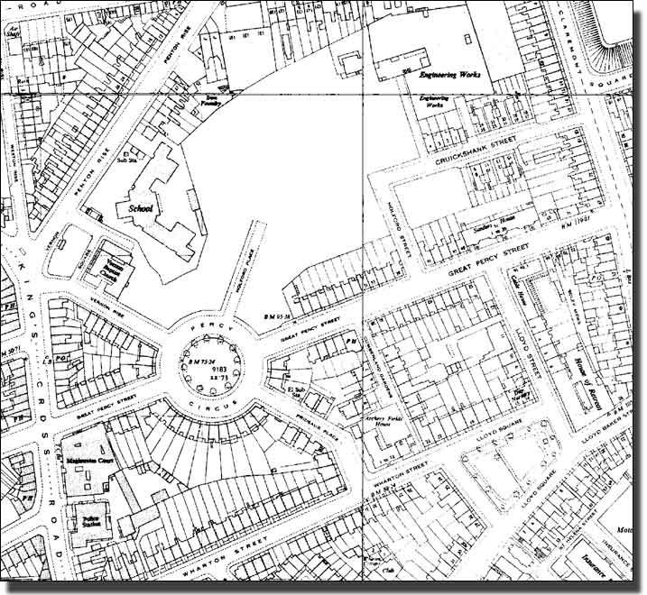
1955 Ordnace Survey map of Percy Circus
(move the mouse over the picture to show the 1915 OS Map)
By 1955 it had been decided to restore and rebuild Percy Circus, but to demolish Holford Square. The map shows this. Holford Place was left, as it is today, as a narrow, rutted road and its houses demolished. The whole of the Holford Square area had been cleared so that it had become a bombsite. Hugh Myddleton School was functioning normally at this time and would do so until the Clean Air Act drove Industry away to the New Towns in the 1970s and school roles fell. Schools numbers fell so drastically that schools had to be amalgamated. The building emptied but lingered on for some years. Today it has been demolished and flats built on the site.
For a teacher the Otterbury Incident by C.Day Lewis is the great book to have. This children's adventure story, with its spivs and adventures on bomb sites sums up the period. Sadly it is out of print but it can be found on the internet, It is a great thing to have in one's bag to enthuse about.

(move the mouse over the front cover above to show the forward)
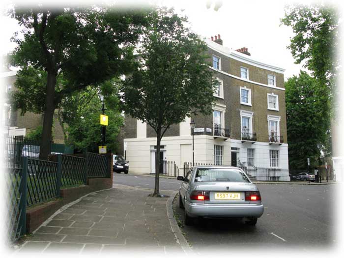
The Restoration and Rebuilding of Percy Circus
The 1955 map shows that some houses in the Circus had been completely demolished, while others were capable of restoration. This is reflected in the present buildings, by the different colours of bricks and new building designs, but the footprint of the Circus has not changed.
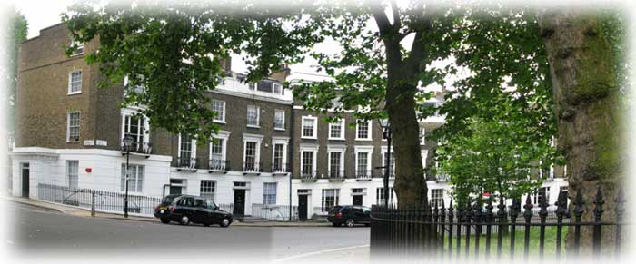
The original Percy Circus houses restored.
The picture above shows the Circus as it has always been. This part, which was not badly damaged, has been carefully restored and could easily have hansom cabs at the doors instead of cars.

Detail of the restored Percy Circus showing the attics and the taller end block and the tall, extra house in the adjoining road. These reversed houses finished off the crescents in a satisfying way and linked them to the adjoining streets. The whole design had been thought out very carefully in a Classical manner.
The entrance into Prideaux Place today.
At one time all the entrances would have looked like this, except that there would have been a projecting porch entrance on both sides instead of only one. Here the right-hand side is as it ever was but the left-hand building was bombed. The porch was destroyed and this arc of the Circus was restored without the entrance in the side road.

This picture is completely different. It is a newly built block with a full extra storey at the top instead of attics. There is no taller building at the end, with a house opening into the adjoining road. Instead the end of the wedge has become one block of flats. The second band of white below the top flats reduces the apparent height of the building but the top floor is like the others and not attics.

This picture shows that Percy Circus lies on a steep, south-facing slope, and basks in the sun like a ca in hot weather. The brick here is different and agrees with bricks in the adjoining road. However, the windows are rendered and painted white and the lower storeys have been rendered and painted like the original Circus houses.
This picture shows that the Circus was redeveloped not as a whole, but as a series of wedges. The Circus houses in this picture were regarded as part of the adjoining roads and the end block has been rebuilt as a block of flats, not separate houses. The colour of the brick comes as a shock but it is true that London Stock Bricks were hard to find at this time, especially as the developers regarded the wedge as a unit and they would have needed vast numbers. The lower floors have been rendered in white to reduce the apparent bulk of the building and the windows look more like the Percy Circus ones than the others further down the road, so the developers did their best.

This wedge of the Circus has been restored as separate houses but here has been much more rebuilding than in the first picture as the bomb damage was more serious here. The rendering of the ground floor in white and the balconies have been restored. The upper floors are completely new, in modern yellow brick, with an extra floor instead of attics and modern sash window with severe, plain surrounds.
This wedge has been restored much as it ever was, although the insides will have been modernised.
 |
This detail shows that one house has been re-fronted in a slightly darker brick and the cornice has not been restored. The bomb must have landed to the left and caused more blast damage to one house than the other. |

This wedge has been completely rebuilt as a four storey block of modern flats. Nothing of the old Circus remains except the floor heights.

Two Percy Circus New-Builds face each other, one in dark red brick and the other in a yellow very like the original London stocks of the original Circus. Both have rendered the lower storeys to match the old design.

The entrance to the Circus from the South showing how steeply the land rises. On the left are the old, restored houses: on the left are newly built blocks.
Percy Circus had been completely restored. The fate of Bevin Court (Holford Square) next door was very different.